East Caribbean: Farewell
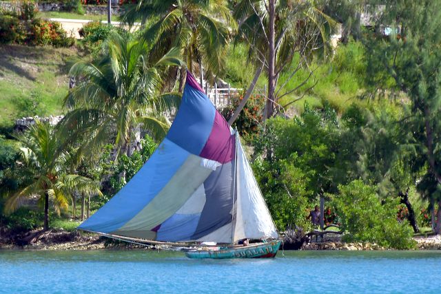
The East Caribbean, also know as the Leeward and Windward Islands, is considered the prime cruising ground in the Americas by many sailors. It includes the Virgin Islands to the north and runs down to Trinidad just off the Venezuelan coast. We struggled to get to the East Caribbean for two seasons before making the 1000 mile passage from the Bahamas to St. Martin in January 2016. We are glad we made the trip, but doubly glad to be back in the Bahamas. There are several reasons we left.
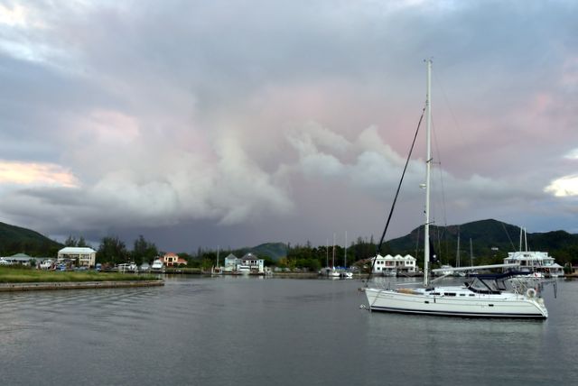
The Weather. Sun and Heat, Wind and Waves. The sun is intense, especially south of St. Lucia and the air temperature, especially on land is very hot. The temperature in the aft cabin where we sleep was consistently in the mid-80° F. Sunscreen plus sweat = sticky skin. The wind is fairly consistently from the NE - E - SE at 15-20 knots, but in the passages between major islands the wind and waves not only compress, making them 30% stronger and higher, but the waves also wrap around the ends, giving virtually all anchorages a roll that rocks boats from side to side, sometimes violently enough to cause glasses in cup holders in the cockpit to fly below decks. Lagoons (St. Martin and Jolly Harbour, Antigua) are the only true respites from the roll.
Safety and Security. There is constant and consistent threat of theft and personal injury to cruisers in every country. Outboards on dinghies need to be locked at all times. Dinghies must chained and locked to the dinghy dock when going ashore and when at the boat. At night, dinghies must be raised out of the water AND locked to the cruiser’s boat. If these procedures are followed, your dinghy will probably not be stolen, but without this amount of vigil, the dinghy, outboard or both have a good probability of being stolen, mainly at night. We personally know cruisers who have gone ashore who have been mugged and injured requiring emergency surgery. Anchored boats are boarded at night and if any resistance is met, cruisers are assaulted and even killed. In St. Lucia there were 10 murders in the first week of January 2017 and one body was found floating in the channel to the marina. If you take precautions and lock yourself in your boat at night, you cut off air circulation with the hatches latched. Some thefts and muggings are reported to the Safety and Security Net, but probably less than half.
Bureaucracy. From the British and US Virgin Islands to Trinidad there are over 20 major islands comprising 19 countries and French Overseas Departments. Each country and French Overseas Department requires cruisers to check in with Customs and Immigration, and sometimes a Port Authority, and also to check out. There is no consistency among the East Caribbean countries, and only Antigua and Barbuda have online pre-clearance. The charges are generally not exorbitant, but if you arrive on the weekend or after 3:45 PM you will be charged overtime (sometimes significant) and some officials ask for donations to local charities (no pressure!) So, when you are traveling between islands you need to consider wind, wave, squalls and also opening hours for the check in / out officials.
The islands we did not visit (and why) were: Virgin Islands, US and British (landed east of them in 2016 and hurricane damage from Irma / Maria in 2017) Anguilla (entry costs), Saba and Statia (poor harbours requiring limited moorings), Barbuda (closed due to hurricane damage in 2017), Monserrat (still recovering from volcano eruptions in the 1990’s), Redonda (no harbour), Barbados (too far east and high entry fees), Trinidad & Tobago (too hot and far south) We did visit St. Martin (both French and Dutch sides), St. Barts, St. Kitts & Nevis (but did not land on Nevis), Antigua, Guadeloupe and her islands, Les Saintes and Marie Galant, Dominica, Martinique, St. Lucia, St. Vincent and the Grenadines (not St. Vincent due to security issues) Grenada, including Carriacou.
Cost of Living. We did not find any “deals” in the East Caribbean. Food prices are significantly higher than in the Bahamas and Canadian. Costs for moorings, dockage, and land storage are higher than any place we have sailed Pilgrim. Chandlery (boat supplies) are not less expensive than in North America, but are not always available in all locations. Local fresh tropical fruit and vegetables are generally available in Guadeloupe and the islands south. Bananas and miniature bananas (dessert figs) and tiny limes have wonderful, distinctive tastes. Tropical vegetables tend to be of the root or squash variety and we have not developed a taste for most of them. In general the French overseas departments (Martinique, Guadeloupe with its outlying islands (Les Saintes and Marie Galante) and the French side of St. Martin had a great selection of reasonably-priced cheese, pate, French wine and locally baked baguettes.
The Passage: Grenada to the Bahamas
1. Grenada to St. Lucia (125 miles) Our first passage from Prickly Bay on the south shore of Grenada to St. Lucia, bypassing Carriacou, St. Vincent and the Grenadines was anything but easy. The forecast was for ESE wind at 12-15 knots and 3-5 foot seas, mild for this area and perfect for a sail NE from Grenada to St Lucia. Instead our wind was 18-22 with gusts to 27 knots from the E or even ENE and 6-8 foot seas. We had the motor on for the entire passage, partially because we needed to desalinate water for our empty starboard water tank and the watermaker takes a great deal of power from the batteries that are already overtaxed with the refrigerator and freezer. But the seas were such that without the motor the waves would have been knocking the wind out of the sails and progress would have been very slow. The mainsail was up the entire passage, and the staysail was unfurled for much of the trip.
In the passage between Grenada and Carriacou just north of Grenada, where we hit major waves last year and lost our 20 pound kellet off the bow, we stayed well off the shallow water which caused such steep waves. Despite this precaution, we managed to bury the bow of Pilgrim in one large wave which then traveled over the foredeck and cabin top and crashed into the front panels of our cockpit enclosure. No damage to the enclosure, but enough salt water got through to make the entire cockpit gritty with salt.
We were making reasonable progress until we got to the halfway mark at St Vincent. The sun set at 5:30, and the crescent moon did not appear until after 1AM, so it was pretty dark. I looked back to check on the dinghy on the stern davits with the outboard often dragging in water as we heeled over. I was aghast at what I saw. The dinghy was swinging wildly from side to side and the solar panels mounted on the davits holding the dinghy were out of position. Brian went below for his safety harness and tools and went to the back deck to inspect. He needed me to steady the boat (in 6-foot seas!), and get us off our port heel so he could jerry rig a solution. Neither one of us had an easy task. We have now discovered that the stanchions supporting the pushpit (stern pulpit) were cracked and corroded and finally gave way, causing the support wires that held the davits in position to slacken. Lesson learned: ALWAYS take the outboard off the dinghy and hang it on the rail for any major passage. After midnight the jerry rig needed some tending, so once again I took the boat into the wind and tried to steady it as much as possible while Brian made some fixes. When we got to Rodney Bay we found a welder in the marina who could repair the damage for the remainder of the season. We were fortunate that we did not loose the dinghy, outboard and solar panels completely, and Pilgrim only had damage to the pushpit.
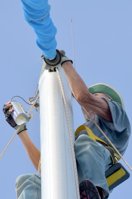
Just before dawn, while I was getting a short rest, the wind instrument panel went blank. It was too dark to tell if the instrumentation was blown off the top of the mast or there was some other problem getting data from the masthead to the display in the cockpit, but it made sailing difficult until dawn when we could see the sails, telltales and windex (non-electronic wind vane at the masthead). Anchored in Rodney Bay, I went to the top of the mainmast, discovered a wire had broken between the wind instrument head and the plug to the cable going down the mast and to the display. I removed the somewhat corroded bolts holding the frame to the top of the mast, managed to unplug the masthead lights and wind instruments and lower the unit to Brian on deck. He repaired the broken wire and I went back up the mast to installed the repaired unit.
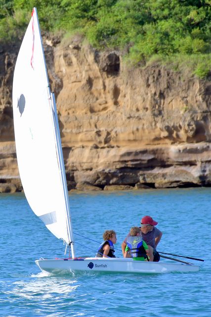
Having fun in Prickly Bay, Grenada Jane up the mast again
To add insult to injury, the first malfunction we noticed when we left Prickly Bay was that our speed log was not registering our speed. We use two different ways of measuring our speed: the speed log, which is a small paddlewheel under the boat that measures how fast the water is moving under the keel, and the GPS, which measures speed over the bottom of the lake, ocean, etc. In strong currents, as in the Niagara River, we have measured 2 knots of “speed” with the log while at a mooring just from the strong water current, but we were not moving relative to the “ground.” It is therefore helpful in situations where there is a current to let you know if the water is pushing or pulling you in a direction you do not want to go. In the Tropics, little critters that live in the ocean like to snuggle up in the paddlewheel when you are at anchor, which can jam the paddlewheel from working. We know our speed log was working when we launched, but 5 days later, it was not working. A minor inconvenience considering all the other issues we faced.
2. St. Lucia to Guadeloupe (150 miles) We managed to repair all our damaged parts during our week at anchor in Rodney Bay, St. Lucia. We left Rodney Bay at 7:30 and had a magnificent sail to the north end of Martinique. Wind was steady 15 knots from the east giving us a steady 7-knot reach and 8-knot surf. We seemed to be ploughing the water causing a large number of flying fish to be active. A couple dozen Caspian terns came diving for the fish. About 10 minutes later the Brown Boobies shooed the terns away and were diving for the fish and also catching some of them in the air as they “flew.” Boobies have the strong, elegant flying and soaring of the Gannet, and the buffoon bellyflop of the Pelican. They love to ride the contrails off our sails and come pretty close to collision with our mast. There were probably 15 of them they kept us company for about 30 minutes of feeding and soaring.
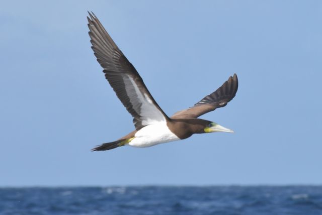
Brown Booby
We had to motor for about 1/2 hour to get around the doldrums the mountains on the north tip of Martinique provided, but then were back to sailing across the Dominica / Martinique Channel. It was sunset as we approached the south end of Dominica. The Caribbean Safety and Security Net has recommended staying 10 miles off the coast of Dominica since there have been several pirating attempts made on passing cruisers. Supplies after Hurricane Maria have been slow to arrive and the people are desperate for food, water and fuel. We went into stealth mode on AIS and kept well off the coast. Dominica is mountainous, so the wind shadow diminished our wind to under 10 knots. Since we wanted to pass Dominica quickly, we turned on the motor and motor-sailed until we were in the channel between Dominica and the Saints (Guadeloupe) at midnight. We had another sail, a bit slower due to lighter wind west of the Saints to the south end of Guadeloupe. We were ahead of schedule and did not want to arrive in Deshaies before dawn at 6:15. Once in the wind shadow of Guadeloupe we were just ghosting along with 5 knots of wind. We motored the last 15 miles to charge our batteries and arrived at 7:00.
We encountered 3 new problems during the passage. First, our fresh water pump started running continuously. There was still 15 gallons of water in the tank. We assumed a leak somewhere. Brian checked the usual suspects for leaks and found none. We simply turned off the water pump At anchor here we discovered the pickup for the water from the tank was above the surface of the water in the tank, which caused the pump to run continuously. It appears we cannot get the last 15 gallons out of the port tank. Not a difficult problem to fix. The second problem was the bilge pump was going on every 15 minutes for 14 seconds. While checking for fresh water system leaks, Brian noticed water coming from under our bunk in the aft cabin and thought the fresh water wash down on the aft deck could have a leak in the hose. When he checked under the bunk, the hose was intact, but water was steadily dripping from the rudder post stuffing box. Fortunately we have extensive information on Whitby 42 “problems” and it seems under high speed and wave conditions, this stuffing box is prone to leak. Third problem was our deck level running lights. We were not planning to have lights on going up the coast of Dominica, but there was an AIS signal 15 miles off Rousseau, the capital, just drifting. The ship name, Luminous Ace, sounded a little ominous. We decided to turn on the deck level running lights. WHAM. The breaker blew; no nav lights. Fortunately we have LED running lights at the main masthead which we turned on. The problem was that the wires for the stern light were inside the pushpit tubing that was welded, and the wire insulation melted.
This is the first year we have been able to use our T-Mobile US SIM cards to access internet data free of charge on the Digicell Network common in the East Caribbean. During both passages we have had Digicell service most of the time. We anticipated it would not be available from Dominica, but were surprised to find 3 bars of service. This enabled us to check out Luminous Ace and discovered it is a Panama-flagged cargo ship for transporting vehicles. How do shipping firms come up with these names?
For years we have watched sunsets in Michigan, Ontario, the Bahamas and East Caribbean watching for the elusive “Green Flash.” We thought the flash was only visible through a Heineken bottle. While passing Dominica, Brian was pretty sure he saw a green flash, but Luminous Ace passed right in front of the sun as it set. At anchor in Deshaies, however, we both saw the flash. The video Brian took is not conclusive, however. It shows a brightness just as the sun sets, but there is no green in the image, only in our eyes.

Great sunset but no green flash
Guadeloupe is a French Overseas Department. Although Hurricane Maria skirted Guadeloupe (Dominica took the direct hit) damage has not been great France has provided disaster assistance and Guadeloupe is open for business. A good bakery and farmers’ market provide good supplies. We had heard from friends who have a boat and house in Jolly Harbour, Antigua, that although Barbuda (30 miles north) had to be closed down after Irma hit, Antigua suffered little damage. We had much more difficulty getting information about the state of repairs on St. Martin. Checking the website of one of the marinas in the Lagoon on the Dutch side, we discovered the resorts were being repaired first, possibly opening in February, 2018, but the marina would be closed the entire winter season. Charter boat companies and resorts gave (perhaps unrealistic) glowing reports of “business as usual.”
After the storm
3. Guadeloupe to Antigua (50 miles) We left Guadeloupe at first light for the 50 mile sail / motor to Antigua’s Jolly Harbour. We had wind for sailing, but had to make water and the desalinator draws 20 amps, so we motor-sailed for all but 1 hour. Seas were high enough to give us a good salty spray, unfortunately after 2 rain squalls washed our decks and sails. We took a mooring at Jolly Harbour, which gave us access to the onshore showers. The water pressure for tepid water is so low you get a dribble of water. For cold showers, you get a better deluge, and in this heat, cold is pretty tepid. Despite the low water volume, it was delightful to have a soapy, non salty bath.
Gathering storm in Jolly Harbour
We began planning and looking for a good weather window to start our 1000 mile passage back to the Bahamas. There were three possible routes to follow: 1. North of the Virgin Islands, Puerto Rico and Hispaniola (Dominican Republic / Haiti), 2. South of the Virgin Islands, Puerto Rico, then up the Mona Passage and North of Hispaniola, 3. South of the Virgin Islands, Puerto Rico and Hispaniola and up the Windward Passage between Cuba and Haiti. We favoured the first and second routes because the third puts an extra 200 miles on the trip. Storms in the north Atlantic kept a steady large north swell plaguing the routes north of the islands. We discussed options with Chris Parker in Marine Weather Center in Florida, and thought we had a reasonable window that would at least get us as far as Île-à-Vache, Haiti, and decided Monday, December 4 was the day to leave Antigua for the 700 (to Haiti) or 1300 (to Georgetown) mile passage.
4. Antigua to Haiti (725 miles) We left Jolly Harbour, Antigua at 9:30 Monday morning, December 4 with Georgetown as our destination, although we were pretty sure we would stop at Île-à-Vache for a rest. Our first day was a boring motor trip to the south shore of Nevis where we altered course slightly for the 500-mile passage to the southern tip of the Dominican Republic in the middle of Hispaniola. When the wind developed on Monday night, it was from the east and built over Tuesday to 15-18, gusting to 22. The 2-foot waves began to build as well. Dead down wind is not Pilgrim’s best point of sail, and we ended up doing a fair bit of downwind tacking to keep up our speed. Tuesday was easy sailing, with the motor on just for charging batteries while the desalinator was running. By Wednesday the waves had built to 6-8 feet and by Friday they were 10-12 feet. It was both scary and exhilarating surfing down the waves at 11 knots. As the trough of a wave passed under our bow, the crest of the wave loomed over the transom and looked as though it would pour over the back deck, but that fortunately never happened. As the crest of the wave passed under the boat and lifted the bow, the dramatic bubbles rose to the surface, making the backside of the wave a beautiful and majestic work of art. Unfortunately we have never been able to capture the beauty and power of the big waves we have experienced.
By Saturday morning we were both very tired. Sleeping happened only when exhaustion overtook us, and for never more than 1 hour. Although the weather forecast was good for going up the Windward Passage (between Hispaniola and Cuba) on Sunday, we felt the need for a calming sleep at Île-à-Vache. To ensure we made it to the anchorage before sunset we motor-sailed, trying to get some protection from the waves by hugging the south coast of Haiti, but we did not have relief from the seas until in the lee of Île-à-Vache.
Île-à-Vache was reported to be cruiser-friendly. However, Haiti is one of the poorest countries in the world and there is very little steady work. As we approached the anchorage, a dozen dugout boats paddled out to welcome us. As we tried to find a location to drop our anchor, these vessels swarmed close to us, they even grabbed onto our rail, attempting to get our attention to provide services to us. We asked them politely to back off, but to no avail. Once we backed on the anchor, we realized the little boats obscured the fact that we anchored right on top of fishing floats. The locals were offering mangos, coconuts, lobster (at $20 US / pound) and maintenance services. They were also asking us for electronic parts, cell phones, earbuds, and the like. Some of the men backed off, realizing we were not in the buying mood, while others refused to hear our polite, firm “NO.” Every day we were anchored, the little boats came out for another attempt to earn money. We ended up buying some sea bass, going ashore for a dinner of BBQ chicken, and having one man come to Pilgrim to cook us a typical Haitian dinner.
Restaurant at the end of the Island
We were carrying many empty water jugs, which were gladly accepted. Brian managed to provide some fishing gear to some of the fishermen and managed to find two earbuds to offer 2 teen-agers. There is one resort on the island, but it had few guests. It had lights on in the evening, but the village where the locals live was very dark. We learned power generation was problematic. Most of the cooking was done with wood fires on hibachis.
One of the better equipped and demanding boat boys
The local official visited us on Sunday and insisted on taking our passports to the mainland to officially check us in to Haiti. We objected, but he insisted. We ended up paying $70 USD. Two other UK boats claimed they were staying just for one night and since the official could not get their passports back before they said they would leave, let them stay without official check-in. We were honest, indicating we were waiting for a weather window, and thus got nailed with the cost. The UK boats left the same morning as us. If the Haitian government were not so corrupt, feathering the pockets of a few rich politicians, we would have felt checking in was helping the country. We still struggle with how we can best support the people in the countries where we sail.
Offering to pay for services is probably the best (but temporary) support, and it is impossible to determine if the person has the skills required for the job you want done.
mainsail raising
Main of many colours
5. Haiti to Georgetown, the Bahamas (560 miles) The Windward Passage is notorious, especially for northbound boats. At best it is a motor trip with no wind. We left IÎle-à-Vache on December 14 and motor-sailed around the SW tip of Hispaniola, then headed NE to hug the coast of Haiti to minimize waves from easterly wind, arriving at the south end of the passage on Friday morning. The wind died and we continued motoring until we cleared the NE tip of Cuba and could take a north course toward Acklins Island in the Bahamas. Finally December 15 at midnight we could sail the 115 miles to Acklins Island, and then another 30 miles NNW to Crooked Island. The sail on Saturday was delightful. There were a few splashing waves, but the wind was a steady 10-13 knots from the NE, giving us a good close reach. We had to motor the last 15 miles when the wind dropped to 7 knots, and anchored in the pitch black at 10:30 on Saturday night at the north end of Crooked Island near Pittsfield settlement.
December 16 we woke to see a beautiful mile-long beach and the characteristic Bahamian blue water. We had a sound sleep and waited 2 days for good sailing weather for the last 115 mile passage up the east side of Long Island, around the northern tip and then SW to Elizabeth Harbour.
The long white beaches and blue seas of the Bahamas
Which long passage was easier? The eastbound passage from the Bahamas to St. Martin in 2016 (1000 miles) or the westbound passage from Antigua to the Bahamas (1285 miles on the route we took)? We thought the westbound passage with the trade winds behind us would be the easy one, but it has not been that easy. Perhaps being 2 years older is showing us our vulnerabilities as we age. In short, we think our long-passage sailing is over.