Newfoundland: Cape Race to Cape Breton Island, July 2012
St. Brides, Avalon Peninsula, western shore: We
left Fermeuse to round the infamous Cape Race and get
to the south coast of Newfoundland.
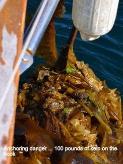
Earlier in the day we hauled anchor only to discover we had anchored in
a major kelp patch, docked at the fish processing plant to fill our water
tanks. Returning to the anchorage we managed to rebed
our anchor in the remnants of the kelp bed. It takes at least 15 minutes to
clear the mess from the anchor every time we do this. WE WISH THEY WOULD PUT
KELP WARNINGS ON THE CHARTS.
We left at 1700 had a great
sail down the east coast to Cape Race, but then at midnight the wind dropped;
unfortunately the sea remained high, keeping our speed down. We motor-tacked along the
south coast at a very slow pace.
Realizing we would not make it across Placentia Bay before nightfall the
next day, and wanting to get a bit further along than Trepassey,
we searched for another harbour and discovered there
were no other safe harbours for a boat our size along
the south shore of the Avalon. The only
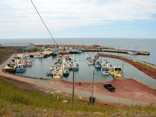
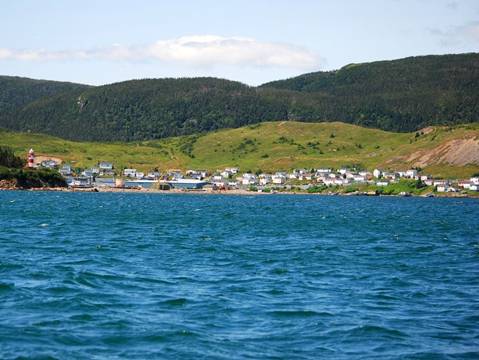
possible harbour is St. Bride's. We arrived at this small fishing harbour mid-afternoon and tied up at the unloading wharf
much to the chagrin of the local fishing folk. The harbour
authority wanted us to raft off a fishing boat in a very confined space if we
stayed longer than overnight. Such a
maneuver could be damaging to all concerned.
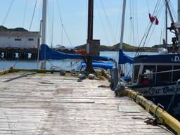
Pilgrim at the unloading dock
The next morning at 5:30 AM
we had to decide to go or stay. The
forecast promised a miserable day with fog and 25 knots of wind on the nose. We
were faced the wrong way at the dock with less than a boat length of
maneuvering room. A fast strategy meeting and a brilliant execution resulted in
no apparent damage to goods or egos while we made our escape. The wind on the
nose did not appear until we approached the east shore of the Burin Peninsula.
The day was in fact a reasonable facsimile of a "good" sailing day.
Five engine hour’s motor sailing and 6 hours of no motor sailing almost
restores one's faith in the power of wind.
The fog appeared about 10 miles off the shoreline, and lifted as we
entered the harbour.
Little St. Lawrence Bay, Burin Peninsula, eastern
shore: The entry into Little St. Lawrence bares almost no
similarity to what is described on the chart. The chart and descriptions would
have you question your sanity as to why you would chose such a tiny place
whereas in reality the area is very large and clear of hazards. You could swing
a whole bunch of cats around and never have them collide. The 20 knot winds at
the entry were a distant memory as we sat in a near dead calm (not the movie)
listening to the call of the loon.
The government wharf had
lines on all sides to prevent tying up … friendly folk
St. Pierre et Miquelon (SPM),
France: Well... not really in France, but France's colony in
North America, about 12 miles off Newfoundland's Burin Peninsula. We had a bit of motoring from Little St.
Lawrence to the southern tip of the Burin, but then the wind came up from the
south, and we had a glorious reach in 12-15 knots of wind... Pilgrim's
(and our) favorite point of sail and wind speed. We entered the harbour
at St. Pierre at 2PM, found a spot to tie up at the visitors' wharf, and were
immediately visited by Customs and Immigration.
The bi-annual
race from Halifax to St. Pierre had just completed, but most of the boats have
already departed. Along with us, the
only Canadian boat, there are boats from Switzerland, France, Germany and the
US. We had power, water, showers,
laundry facilities and WIFI, but it was expensive. St. Pierre et
Miquelon is in a different time zone from Newfoundland: ½ hour ahead of Newfoundland, 1 hour ahead of
Atlantic Canada. All business stops at
noon until 1:30 for lunch. Most shops
are closed by 5PM. Cigarette smoking is
prevalent; the electrical power system is 220V 50 cycles.
Our
expectations had been set a little too high by our two cruising guides. We expected to feel like we were back in Europe,
with French products on the shelves in the grocery stores. Everything was very expensive, from the
dockage fee to the tour to Miquelon to the food and drink prices. The products on the shelves were Canadian
brands; the fresh produce was disappointing, and there was no fresh fish. We finally found a specialty market with some
good French cheese and great Spanish chorizo.
The
buildings in St. Pierre are set right on the street; open the door and look
both ways before jelly bean houses were tastefully painted; here they were just
strange colour combinations. Lace curtains hang in most of the
windows.
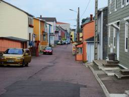
The
buildings generally seem somewhat rundown.
Quite a few buildings were vacant.
There is little industry in St. Pierre and the fishing has dried up as
much as in Newfoundland. The area is
heavily subsidized by France; probably due to pride in having North American
territory. Many are government workers. All have free education in SPM through high
school, and if they want it, free university in France. There is a strong sailing program for kid. We haven't seen such an active sailing
program for kids since Cork, Ireland. We
think that people who live on an island need to feel comfortable in a boat.
Miquelon
looks like an hourglass. The lower bulb
is the island Langlade. The upper bulb
is Miquelon. The two bulbs are joined by
a very narrow sand isthmus. As late as
the nineteenth century boats could pass between the two islands, but the water
was shallow and there were many shipwrecks.
The shipwrecks were useful catchers of silt, and eventually the isthmus
was complete. Langlade has high steep
cliffs on the south and east faces, with some sea stacks, arches and
caves. The isthmus and Miquelon are
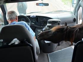
flat, low and sandy. Semi-wild horses
live on the isthmus. They are
descendents of shipwrecked animals. The
horses are trained to beg for bread from any vehicle that slows down. Some attempts have been made to farm the
land, but the only successful crop has been potatoes, and this crop is not big
enough to be sustainable.
Our
tour started in St. Pierre in a Zodiac powered by two 75HP motors. It was not enclosed, and the ride back,
against the waves, was very bouncy and wet.
The tour could accommodate 20 folks, but there were only 5 on our trip. It was very foggy, rained off and on, and
became quite windy in the afternoon. The
rookery on Grand Colombier Island was barely visible
with its hundreds of puffins, guillemot and razorbills. The "wharf" at Anse
Du Gouremement
on the NE bay of Langlade was a couple of planks; Zodiacs got as close
to shore as possible, the plank was laid down, and you jumped from the boat
onto the plank, hoping to keep your feet dry.
Unloading baggage was done by chain of folks throwing items from one to
another up the beach.
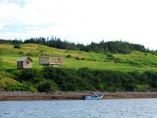
There
is a substantial group of cottages at Anse Du Gouremement. They
have wind and fuel-powered generators, but no running water, electrical or
sewage system. Residents of St. Pierre
own these cottages and enjoy "roughing it" away from the bustle of
St. Pierre in the summertime. In
addition to the tour boat, a ferry service is run during the summer. There is also a ferry that runs between St.
Pierre and the city of Miquelon at the north end of the island Miquelon. Many of the cottages had extensive and
well-kept gardens, including some vegetables, which may have explained why
there were few gardens in the city of St. Pierre. The only religion is Roman Catholic, and
there are cathedrals in both St. Pierre and Miquelon with several chapels
outside of the cities. The church in
Miquelon had extensive artwork: statues,
stained glass windows, and murals. The
wooden pillars are painted to look like marble.

Two
of our days in St. Pierre we had dense fog and rain. Except for one evening we had strong winds,
mainly from the west. We left St. Pierre
in NW winds at 20 knots. By the time we
were away from the islands, the wind speed was 10-15. We felt tourism was minimal while we were
there. After we arrived, 4 other sailboats
arrived and departed the following day.
(2 Canadian, one US and one German)
Two other boats were on the visitor's wharf when we arrived and still
there when we left.
We
are glad we made the stop at St. Pierre et Miquelon;
it was not what we expected, but it was most pleasant.
Fortune, Burin Peninsula, western shore: We
had a very good sail the 25 miles northeast to Fortune Harbour
with NW winds. A couple of Orcas were
spotted briefly. No Finbacks, which we
had hoped to see. Canadian Customs and
Immigration visited us and cleared us back into Canada. The harbour has
recently been expanded to accommodate boats (and cars) from St. Pierre. It seems many from SPM have homes and cars in
Fortune so they can make shopping excursions to Newfoundland for less expensive
and greater selection of goods. The
parking lot at the floating docks had more SPM cars than Newfoundland
cars.
A
sailboat from St. Pierre came into the harbour around
8:30 PM. First they ran aground. Then they decided to dock ahead of Pilgrim
with a strong wind blowing them off the dock.
Brian ran to catch lines, much to the relief of the woman on the
bow. The French male on the wheel seemed
a bit miffed that assistance was accepted and that his wife (?) didn’t make the
6 foot jump to the dock. Fortunately
Brian was taming the bow line and keeping the backing vessel from slamming into
our bow pulpit. As we departed Fortune,
a small dory with an outboard came in the channel with an erratic course. The helmsperson was busy with the outboard
and did not even see that he swerved right into our bow, until his companion
and Brian yelled at him. I think we
would have inflicted more pain on them than they on us.
Jerseyman’s Cove, Fortune Bay: We
had another GREAT sail from Fortune, NL to this cove due north. 15-20 knots of wind from
the west. We have observed that
there is little sea swell in these waters, just wind
waves. We still got some salt spray, but
the waves did not slow our speed today.
The water is a beautiful turquoise, much like in Norway.
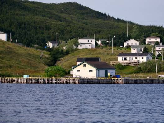
Jerseymen's Cove was an outport community in the cod heyday, but there is very
little left of the settlement. Two new
cottages are under construction. It is
amazing how quickly wooden buildings crumble when no one lives in them or
repairs them. The headstones in the
cemetery are still standing on a knoll at the entry of the harbour,
but only shadows of the foundations remain from the buildings.
Brent’s Cove, Faucheux Bay,
Southwest coast: We were truly isolated. No internet.
No mobile phone. No people. Even SSB transmission was poor. Facheux (fore SHOO) Bay is the eastern-most fjord, and Brent Cove is
an indentation about 4 miles north of the entrance. The bay is 1100 feet deep, and the cliffs are
1100 feet high. As in Norway, it is
impossible to get a sense of the scale until you see something familiar, like a
little shack or cottage (there are 3 we have seen)that look like dolls houses. In Brent Cove there is an abandoned hunting
lodge and decaying wharf. There are also
a couple of loons and their calls are echoed against the high cliffs. The winds were a bit chaotic and "blow
me down" because the wind blows across the cliff tops, then drops to the
water level.
As
we approached the bay, from about 10 miles out, we could see a major fog bank
between us and the land, with the high cliffs towering over the fog bank. As we got closer to the bay entrance, the fog
seemed to part, making us feel a bit like Moses. Radar was ready, but not needed.
Newfoundland
names go from the sublime to the mundane.
The two heads that flank this bay are Western Head and Eastern
Head. However, we do like the tiny cove
called Doughboy Cove.
We
took the dingy out to try out the outboard, which hasn't been used since 2010. All worked well. We visited the abandoned hunting lodge and
found moose tracks and lots of bugs.
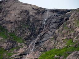
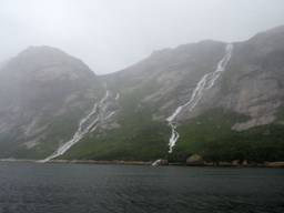
Deadman’s Cove, La Hune
Bay, Southwest coast: We passed half a dozen more deep fjord-like bays
running N/S to La Hune Bay. Where Facheau was
reminiscent of Norway, without the waterfalls, snow, glaciers, sheep and
pastoral farms, La Hune is dramatic, but without the
cliffs plunging straight down into the bay.
We do have a "bridal veil" waterfall coming down a 600-foot
high cliff. There are few birds and no
animals here.
Before the rain
After the rain
We
did not intend to spend 2 nights in La Hune Bay, but
we had no choice. When we arrived the
wind was less than 10 knots from the SW.
This anchorage had steep cliffs to the north, less steep cliffs to the
south, a low hill to the east, and was open to the west. When the wind increased from the south, to 20
knots as we got to bed, it hit the north cliff face, diverted and sped up ...
called a Katabatic wind, or in Newfoundland a
"blow me down." The wind hit
Pilgrim from different angles and at gusts up to 32 knots, causing us to swing
wildly on the anchor. Brian kept watch
in the cockpit all night until dawn, when the wind diminished. The wind remained strong from the south all
day on Wednesday. We were able to deploy
our Danforth as a second anchor, and that helped us
from swinging so violently. The rain
started and was very heavy. There was no
way we were venturing out. By evening
the wind was slightly calmer, but the rain remained heavy. When we woke up the second morning the single
waterfall had swollen, and there were 4 other falls from the "pond"
at the top of the cliff.
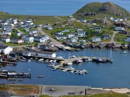
Ramea Island, southwest coast: From
La Hune we sailed to Ramea
downwind tacking with 18 knots from the east.
There are about 600 residents in this outport
village, but we cannot figure out how the village survives. The fish processing
plant has closed, the fishing wharf is deteriorating beyond use, the government wharf where we are tied has many rotten
planks and is filled with unused fishing boats.
We have tied across the end of the wharf, the only spot we could
find. The long floating dock that we
understood was to be for visiting boats has local boats spaced so that there is
no space for visitors. In one of our
cruising guides there is an ad for Rameau, promising power and water, but there
are only 15 amp outlets on the wharf and none on the floating dock. No water.
It is hard for us to understand how this place continues, and requires 3
trips from the ferry each day.
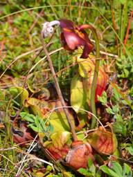
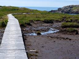
We
had a great walk on the extensive boardwalk that allows one to hike on the
bog. We saw our first Pitcher Plant
(Newfoundland's Provincial Flower), but the blossom had dried up and the plant
looked somewhat sinister.
Great Bras d’Or Channel, Cape Breton Island, Nova
Scotia:
We
left Ramea Island at 8AM on and sailed with a gentle
NW to W wind (double headsail meant we could sail a good angle to the wind) until
the wind lightened at midnight and backed further west. We motored the rest
of the way to Cape Breton Island with seas that reflected like glass there was
so little wind. The only sea mammals
sighted were seals as far as 35 miles from shore.
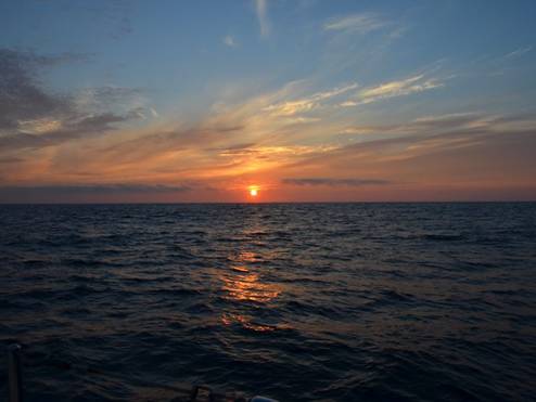
OUR
LAST Newfoundland sunset
As
we motored into the Great Bras d'Or Channel, a light wind behind us boosted our
speed through the water to 6+ knots but a 4-knot current against us (ebb
current) slowed us down to less than 2 knots.
At one narrow location in the channel, we were right next to a
whirlpool. We looked over the port rail
and it looked as though there were circular steps in the water. It was a no-brainer to anchor in Kelly Cove
and wait for a favorable current than slug our way further up the channel.
The
following day we closed the loop on our North Atlantic circumnavigation. We were in Baddeck
in July 2006 and returned here in July 2012.
In between we crossed the Atlantic to Europe using the middle route
(Bermuda, Azores) and crossed back to North America last year using the
northern route (Iceland).